2.0 Property Design
Site Data Collection Checklist
Before you start planning or expanding your farm operation, this is some of the information that you will need to collect. This checklist has been adapted from Richard Perkins’ book, Regenerative Agriculture (p.68) and from Shelaigh Garson (Everyone’s Eden).
- Basic
- Topography
- Views – desirable or undesirable
- Risk of wildfire, flood, frost, etc.
- Noise or pollution
- Off-site concerns: Unpleasant odours, dust, privacy, etc.
- Map
- Legal property lines (the City of Kamloops map and TNRD map)
- Location of existing utility/water/gas lines (Click Before You Dig)
- Location of sewer/septic system
- Location of water access
- Aerial photos (Google Maps or with a drone)
- Contour map (the City of Kamloops map and TNRD map)
- Determine slope gradient
- Identify keylines, valleys, and ridges
- Climate
- Light availability – How does the sun, rain, clouds, fog impact the light?
- Average rainfall (monthly and annually)
- Temperature (hardiness zone)
- Solar aspect – Find the solar aspect through the seasons; find the solar aspect on June 21 (longest day of the year) and December 21 (shortest day with the least sun) using online tools.
- Wind aspect – Where does the wind come from? Does it change through the seasons or time of day? You might want to design wind breaks if any spots are particularly windy.
- Water
- Water quality
- Existing water rights
- Drainage patterns
- Springs, creeks, ponds, rivers
- Flood levels (50 or 200 year flood)
- Access
- Location of driveways
- Wildlife – Are there common access points of deer or other wildlife moving through the property?
- Structures
- Location of buildings, greenhouses, compost systems, etc.
- Trees
- Existing trees and how healthy they are
- Density
- Soils and Geology
- Soil assessment (3.0 Soil Health)
- Soil type
- Soil tests for nutrient levels (3.0 Soil Health)
- Try to find out the history of the property
Property Design
When designing your property (either from scratch or with existing infrastructure), using the framework of water, access, and structures will help guide you through the process.
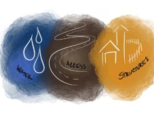
1. Water
Whether it’s a hose, or a river, you have to consider where your water is coming from, and what your water needs are.
- Where is your water coming from?
- Do you need a pump system?
- Do you need irrigation? What will your system need?
- Can you incorporate natural systems into water harvesting? Is there a wetland on the property?
- Do you need to harvest water, or do you have lots of water on your property?
Reference 2.2 Water Access and Irrigation for more information.
2. Access
- Where is the sun? Where does the wind come from?
- What are the contours of your land?
- How are you going to access various areas of your food production facility?
- How will you access the structures; consider the house, growing area, wash station, water access, food storage, roads, walking pathways, etc? What are the easiest pathways to get to each structure?
- Consider footpaths, walking time, and permaculture zones
3. Structures
- Infrastructure includes house, greenhouse, wash stations, tool storage, food storage
- Rock bluff
- Stand of trees
-
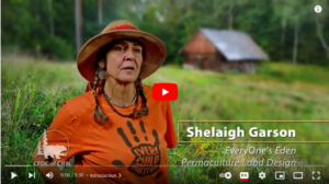
- Shelaigh Garson’s Video
-

- Scan QR code to watch video
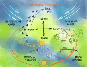
Sector Analysis
Activity: Conduct a Sector Analysis on your property
- Start with a site plan – Find a map that includes legal property lines (the City of Kamloops map), and the location of existing utility/water/gas lines and sewer/septic. You can also find or take aerial photos (Google Maps or with a drone) for the birds-eye view.
- You can also get more detailed maps that include contour lines, slope gradients, valleys, and ridges.
- Overlay your map on a piece of graph paper, and plot the water, access, and structures on the property:
- Water (water hydrant, faucet, irrigation, well, river, pond)
- Access (driveways, roads, paths)
- Structures (house, greenhouse, shed)
- Then, work through the main sectors that will impact your farm:
- Sun – What is the path of the sun on June 21 (longest day of the year) and December 21 (shortest day of the year)?
- Wind – Where are the morning and afternoon winds? Do they change through the Summer and Winter?
- Wildlife – Where are the deer and other wildlife moving through the property?
- See the site checklist above for more ideas to put on your analysis.
You can also incorporate permaculture zones into your design:
- Zone 0: The people and your house, and other areas you are in multiple times a day.
- Zone 1: Areas that you visit daily (e.g. kitchen herb garden, chicken coop)
- Zone 2: Areas you visit weekly (e.g. greenhouses, high maintenance crops, shed, compost bin)
- Zone 3: Areas you visit semi-regularly (e.g. low maintenance crops, fruit and nut trees, bee hives, cattle).
- Zone 4: Areas that are mainly wild, but managed occasionally (e.g. harvest wood for firewood or have native plants for wildlife).
- Zone 5: Wild areas where wildlife frequent.
Permaculture
Permaculture is a combination of perennial systems that work in conjunction with one another, in a forest ecosystem, growing food, medicine, or fibre. It involves designing with plants with a purpose that gives back to the natural system and has a yield for humans, but not at the cost of the system. One example of a permaculture practice is a Food Forest, where trees and shrubs and other perennials are planted in such a way to support each other’s natural functions.
Further Reading
If you want to learn more about design principles, you can look into permaculture books (suggested below), or holistic management.
- Principles of Permaculture website
- Verge Permaculture: Website and YouTube channel
- The Permaculture Handbook: Garden Farming for Town and Country by Peter Bane
- Gaia’s Garden: A Guide to Home-Scale Permaculture by Toby Hemenway
- Regenerative Agriculture: A practical whole systems guide to making small farms work by Richard Perkins